Typhoon Ragasa is expected to enter the East Sea on 22-September-2025 and to make landfall in Vietnam some time from 25-September-2025. Let us monitor this typhoon and see how your Vietnam holidays and Vietnam tours are affected.
20-September-2025
1900: Typhoon Ragasa's position: (17.3°N; 128.5°E), 650km east of the Luzon Island (the Philippines); wind speeds: 134-149 kph; projected path: northwest traveling at 15-20 kph.
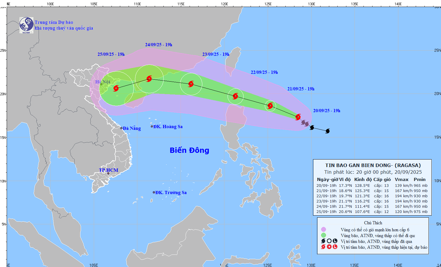
21-September-2025
0700: Typhoon Ragasa's position: (17.9°N; 127.0°E), 520km east of the Luzon Island (the Philippines); wind speeds: 150-166 kph; projected path: west northwest traveling at 15 kph.
1300: Typhoon Ragasa's position: (18.5°N; 126.2°E), 430 km east of the Luzon Island (the Philippines); wind speeds: 150-183 kph; projected path: west northwest traveling at 15-20 kph.
1900: Typhoon Ragasa's position: (18.9°N; 125.4°E), 350 km east of the Luzon Island (the Philippines); wind speeds: 184-221 kph; projected path: northwest traveling at 15-20 kph.
22-September-2025
0100: Typhoon Ragasa's position: (19.2°N; 124.1°E), 230 km east northeast of the Luzon Island (the Philippines); wind speeds: 184-221 kph; projected path: west northwest traveling at 20 kph.
0700: Typhoon Ragasa's position: (19.3°N; 123.1°E), 160 km northeast of the Luzon Island (the Philippines); wind speeds: 202-221 kph; projected path: west northwest traveling at 20 kph.
1300: Typhoon Ragasa's position: (19.4°N; 121.7°E), 140 km north of the Luzon Island (the Philippines); wind speeds: 202-221 kph; projected path: west northwest traveling at 20-25 kph.
1900: Typhoon Ragasa's position: (19.5°N; 120.5°E), sea area to the northwest of the Luzon Island (the Philippines); wind speeds: 202-221 kph; projected path: west northwest traveling at 20-25 kph.
In the evening, Typhoon Ragasa enters the East Sea becoming Typhoon No. 9 in 2025.
2200: Typhoon Ragasa's position: (19.5°N; 119.9°E), sea area to the northeast of the North of the East Sea; wind speeds: 202-221 kph; projected path: west northwest traveling at 20-25 kph.
23-September-2025
0700: Typhoon Ragasa's position: (19.9°N; 118.3°E), sea area to the northeast of the North of the East Sea; wind speeds: 202-221 kph; projected path: west northwest traveling at 20 kph.
0900: Typhoon Ragasa's position: (20.1°N; 117.9°E), 820 km east of the Leizhou Peninsula; wind speeds: 202-221 kph; projected path: west northwest traveling at 20 kph.
1600: Typhoon Ragasa's position: (20.6°N; 116.7°E), sea area to the northeast of the North of the East Sea; wind speeds: 184-201 kph; projected path: west northwest traveling at 20 kph.
1800: Typhoon Ragasa's position: (20.7°N; 116.3°E), 640 km east of the Leizhou Peninsula; wind speeds: 184-201 kph; projected path: west northwest traveling at 20 kph.
24-September-2025
0400: Typhoon Ragasa's position: (21.3°N; 114.3°°E), 650 km east of Mong Cai (Quang Ninh); wind speeds: 167-201 kph; projected path: west northwest traveling at 20 kph.
0600: Typhoon Ragasa's position: (21.3°N; 113.9), 380 km east of the Leizhou Peninsula; wind speeds: 167-201 kph; projected path: west northwest traveling at 20 kph.
0700: Typhoon Ragasa's position: (21.3°N; 113.7°E), 360 km east of the Leizhou Peninsula; wind speeds: 167-183 kph; projected path: west northwest traveling at 20 kph.
0900: Typhoon Ragasa's position: (21.3°N; 113.2°E), 570 km east of Mong Cai (Quang Ninh); wind speeds: 167-183 kph; projected path: west northwest traveling at 20 kph.
1000: Typhoon Ragasa's position: (21.3°N; 113.2°E), 570 km east of Mong Cai (Quang Ninh); wind speeds: 167-183 kph; projected path: west northwest traveling at 20 kph.
1500: Typhoon Ragasa's position: (21.5°N; 112.3°E), 470 km east of Mong Cai (Quang Ninh); wind speeds: 150-166 kph; projected path: west northwest traveling at 20 kph.
1900: Typhoon Ragasa's position: (21.6°N; 111.4°E), 375 km east of Mong Cai (Quang Ninh); wind speeds: 118-133 kph; projected path: west northwest traveling at 20 kph.
25-September-2025
0400: Typhoon Ragasa's position: (21.5°N; 109.5°E), 170 km east of Mong Cai (Quang Ninh); wind speeds: 75-88 kph; projected path: westwards traveling at 20 kph.
0700: Typhoon Ragasa's position: (21.5°N; 108.9°E), 100 km east of Mong Cai (Quang Ninh); wind speeds: 62-74 kph; projected path: westwards traveling at 20 kph.
0900: Typhoon Ragasa's position: (21.5°N; 108.5°E), 60 km east of Mong Cai (Quang Ninh); wind speeds: 62-74 kph; projected path: westwards traveling at 20 kph.
1000: Typhoon Ragasa has weakened to be a tropical depression. The position: (21.5°N; 108.4°E), 40 km east of Mong Cai (Quang Ninh); wind speeds: 50-61 kph; projected path: westwards traveling at 15-20 kph.
1200: The tropical depression's position: (21.6°N; 108.0°E), sea area on the coastline of Quang Ninh; wind speeds: 39-49 kph; projected path: westwards traveling at 15-20 kph.
1300: The tropical depression's position: (21.5°N; 107.8°E), sea area on the coastline of Quang Ninh; wind speeds: < 39 kph; projected path: westwards weakening further before melting away. This is the last update on Typhoon Ragasa.