Tinh Yen Bai Holiday Weather today
Date/time of update: August 1, 2026, 12:05 am, Timezone: GMT+7
Light Rain
Temperature: 23.73°C
Temperature feels like: 24.77°C
Minimum Temperature: 23.73°C
Maximum Temperature: 23.73°C
Atmospheric pressure: 1007hPa
Humidity:100%
Visibility: m
Wind speed: 0.68m/sec
Wind Direction: 36 degrees
Cloudiness: 93%
Sunrise: 2026-07-31 10:34:13
Sunset: 2026-08-01 11:41:01
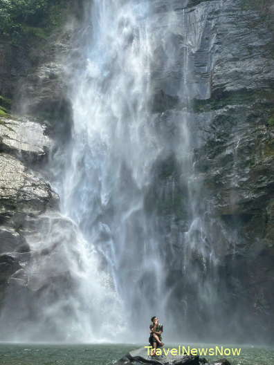
Hang Te Cho Waterfall is in Lang Nhi Commune, Tram Tau District, Yen Bai Province. The waterfall, which is 50m high, is on an elevation of over 1,800m above sea level. Hang Te Cho is in an isolated location surrounded by high mountains with several patches of forest.
Travel Guide to Hang Te Cho Waterfall, Tram Tau, Yen Bai
It is extremely difficult to get to the waterfall for the appalling road conditions.

How to get there
Travel from Hanoi to the Muong Lo Valley via Route 32. Before we reach the Muong Lo Valley – Nghia Lo Town, and just after we have passed the People’s Committee of Van Chan District, we turn left at the Township of Nghia Lo Farm (Thi Tran Nong Truong Nghia Lo) and travel southwest following a small paved road to Phing Ho. This leg of the journey is 10km.
From Phinh Ho, continue southwest for another 10km onto a small dirt trail with some parts strewn with rocks and gravels and some parts with slippery soil. The route goes uphill and is steep and in bad conditions all the way to Lang Nhi.
After we pass Lang Nhi Commune the route gets more difficult with steep gradients up and down all the way for another 10km to the Hang Te Cho (Hang De Cho) Village.
The last leg of the journey is on foot for over 1 hour via a tiny trail on a steep mountain slope all the way to the base of the waterfall.
Yen Bai Average Monthly Rainfalls and Temperatures